Derek’s Five Best-Loved Downtown Calgary Cycle Circuits and Cool Coffee Cafés
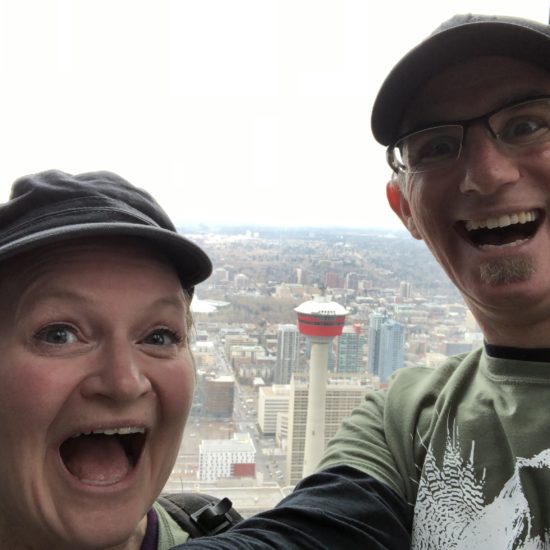
I do love exploring Calgary on my bicycle. I think the enjoyment of it was enhanced by my days working in the Beltline as an engineer when I would do my 20km cycle from home in the northwest to work. It was always such a thrill as I commuted along the cycle path, parallel to Deerfoot Trail, passing by the Telus Spark Science Centre, veering west at the Bow River, meandering past the Zoo and onward into downtown. I was a little less eager about the cycle home, but that’s the nature of cycling a circuit: “what goes up must come down”, right? What was easy in one direction will require more effort on the return journey.

With that in mind, here is a list of some of my best-loved downtown cycle routes that I enjoy doing with Christa or with friends when they visit us in Calgary. Please take a moment to share with us which of these routes you like best. Or share with us your favourite Calgary cycle circuits so we can explore and discover more for ourselves.
My Favourite Downtown Cycle Circuits and Cafes
All cycle circuits begin and end in Calgary’s East Village at the city parking lot CPA Lot 74. There is ample long-term paid parking in the area. For convenient payment, download and use the City of Calgary Parking App. Remember that parking on the weekends carries a flat rate of only $2.

1. 🚴🏻Westbound Bow River Pathway (northwest & southwest quadrant)
| Cycle distance: | ~12.4km |
| Elevation change: | ~28 metres |
| Cycle time (without stops): | ~45 minutes |
| Difficulty: | Easy |
| Cycle terrain: | Dedicated cycle pathways; some street cycling and intersection / crosswalk crossings required |
| Recommended snack stops: | Sidewalk Citizen Café / Higher Ground Café / Made By Marcus Ice Cream / Alforno Bakery & Café |
| Circuit highlights and attractions: | Bow River pathway; George C. King pedestrian bridge at St Patrick’s Island Park; Memorial Drive; Centre Street Bridge; Prince’s Island Park; Peace Bridge; Poppy Plaza; Kensington neighbourhood; Eau Claire Market; Chinatown Riverfront Avenue |
| Downloadable map: | https://goo.gl/maps/bd83ATP6AmkGiHV76 |
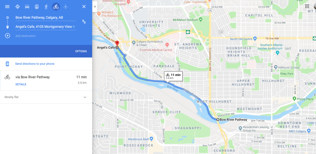
| Additional comments: | For a slightly longer ride (3.6km one way), continue westbound along the Bow River pathway from the Crowchild Trail intersection, parallel to Memorial Drive to the Edworthy Park pedestrian bridge. Explore the Park. Enjoy a refreshment break at the newly face-lifted Angel’s Café. A downloadable map of this segment is available here. |


2. 🚴🏻 Eastbound Bow River Pathway through Inglewood (southeast quadrant)
| Cycle distance: | ~11.4km |
| Elevation change: | ~25 metres |
| Cycle time (without stops): | ~39 minutes |
| Difficulty: | Easy |
| Cycle terrain: | Dedicated cycle pathways; some street cycling and intersection / crosswalk crossings required |
| Recommended snack stops: | Rosso Coffee Roasters / Spolumbo’s / Scarpetta Italian Eatery |
| Circuit highlights and attractions: | Bow River pathway; Elbow River; Inglewood (residential); discover more at the Sam Livingstone Fish Hatchery; Pearce Estate Park; visit the Inglewood Bird Sanctuary (no cycling inside the sanctuary but bicycles can be securely locked at the interpretive centre); check out the river surfing at Harvie Passage viewing site; south perimeter of Calgary Zoo; explore St Patrick’s Island Park; George C. King pedestrian bridge |
| Downloadable map: | https://goo.gl/maps/19eDTFBHFaBm7U949 |
| Additional comments: | For a slightly longer ride (1.3km one way), continue from Zoo Road to the neighbourhood of Bridgeland. Enjoy a snack at the Bridgeland Market or any of numerous trendy snack locations in the area. A downloadable map of this segment is available here. |


3. 🚴🏻 Southbound beyond Stampede Park including city skyline views (southeast quadrant)
| Cycle distance: | ~7.4km |
| Elevation change: | ~63 metres |
| Cycle time (without stops): | ~30 minutes |
| Difficulty: | Easy / Moderate |
| Cycle terrain: | Dedicated cycle pathways; street cycling and intersection / crosswalk crossings required |
| Recommended snack stops: | Reader’s Garden Café / Rosso Coffee Roasters – Ramsay / Red’s Diner in Ramsay |
| Circuit highlights and attractions: | Bow River pathway; Elbow River; Reader’s Rock Garden; Scotsman’s Hill city skyline viewing site; Scotia Bank Saddledome; Stampede Park |
| Downloadable map: | https://goo.gl/maps/T4uGSzR8c2ThX5zv9 |
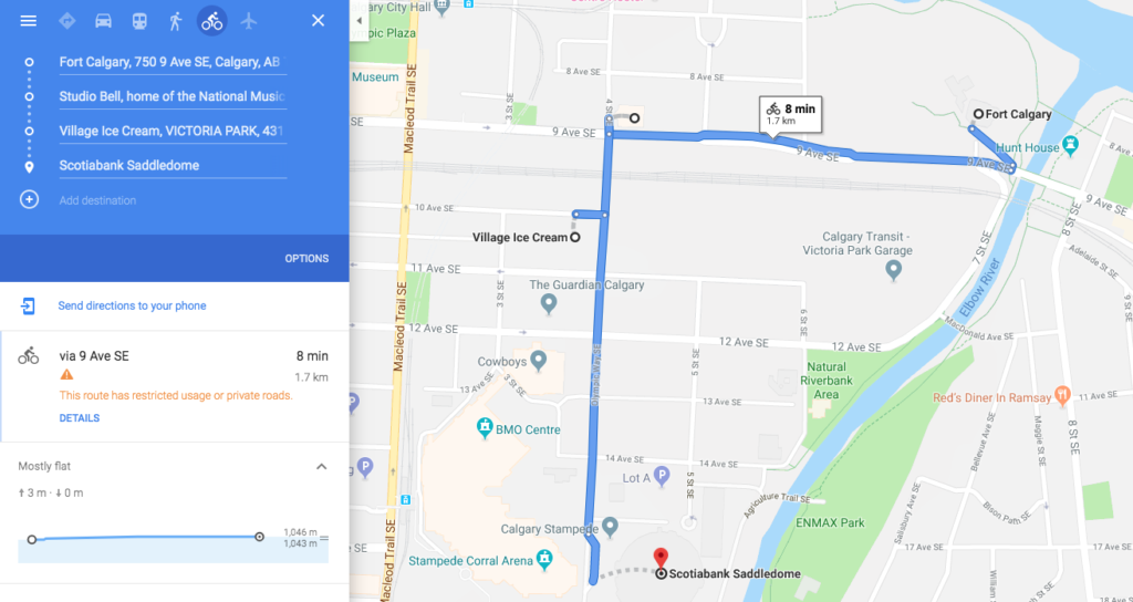
| Additional comments: | For a slightly longer ride (1.7km one way), continue eastbound along 9th Ave SE from Fort Calgary to the National Music Centre (Studio Bell). Turn south and continue along 4th Street SE. You will arrive at the entrance to Stampede Park. Here you can explore the grounds of The Greatest Outdoor Show on Earth – the Calgary Stampede. Swing by the beloved Village Ice Cream for a treat as you return to your vehicle and the start of this cycle circuit. A downloadable map of this segment is available here. |


4. 🚴🏻 Bow River Pathway eastbound to TELUS Spark Science Centre (northeast quadrant)
| Cycle distance: | ~8.4km |
| Elevation change: | ~54 metres |
| Cycle time (without stops): | ~30 minutes |
| Difficulty: | Easy / Moderate |
| Cycle terrain: | Dedicated cycle pathways; street cycling and intersection / crosswalk crossings required |
| Recommended snack stops: | Bridgeland Market / OEB Breakfast Co. |
| Circuit highlights and attractions: | Bow River pathway; George C. King pedestrian bridge; St Patrick’s Island Park; Calgary Zoo perimeter; Tom Campbell’s Hill Natural Park and city skyline viewing site; Bridgeland neighbourhood |
| Downloadable map: | https://goo.gl/maps/ULrbLNWjnbEXxqWX9 |
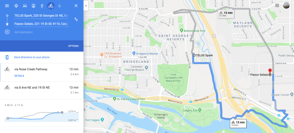
| Additional comments: | For a slightly longer ride (3.4km one way), follow the downloadable map here that will take you to the ice cream “heaven” and coffee shop at fabulous Fiasco Gelato. |


5. 🚴🏻 I AM CALGARY’s “Four-by-Four” Circuit
For the more ambitious cyclist and tourist, try our recommended Four-by-Four circuit. This circuit will allow you to touch on all four quadrants of the city in this uniquely configured route for the slightly more cycle-savvy.
| Cycle distance: | ~10.3km |
| Elevation change: | ~96 metres |
| Cycle time (without stops): | ~43 minutes |
| Difficulty: | Moderate |
| Cycle terrain: | Dedicated cycle pathways; street cycling and intersection / crosswalk crossings required |
| Recommended snack stops: | Cyclist-friendly with an outdoor patio and free air for pumping bicycle tires at Alforno Bakery & Cafe |
| Circuit highlights and attractions: | Bow River pathway; George C. King pedestrian bridge; Rotary Park and city skyline views; McHugh Bluff / Crescent Road NW city skyline views; Peace Bridge; Prince’s Island Park; Eau Claire Market; Chinatown; Riverfront Avenue |
| Downloadable map: | https://goo.gl/maps/kV5j1Ja5nnkbV69AA |
| Additional comments: | Watch a YouTube video on our channel of this similar route |


If you don’t have wheels of your own to enjoy one of these circuits, then consider embarking on one of these memorable rides by renting a vintage-style cruiser bicycle from Rath Bicycle, located in the pink container in the East Village along River Walk.
You may also want to check out our outdoor cycle circuit that takes you to see some of our favourite downtown outdoor sculptures and ice cream spots!
✅ Checklist: what to bring along
- Cycle helmet
- Sunglasses
- Camera
- Water bottle
- Sun screen
- Cycle-friendly footwear
- Small backpack
- Bicycle pump
- Weather-appropriate clothing
- Downloaded maps
Optional:
- Puncture repair kit
- Binoculars
- Downtown tourist city map (paper version)